UAV Wingman.
Weather, DGCA airspace & flight safety for Indian drone pilots.
Stop paying $30 to $50 every year for foreign apps that do not know Indian DGCA Green Zones, 42°C summer battery limits, or Guntha survey units. UAV Wingman brings the iconic clarity of UAV Forecast to Indian skies, engineered in Mumbai specifically for how we actually fly in India.
Stop paying foreign prices
for apps that ignore India.
Indian drone pilots have spent years juggling separate apps for weather, Indian airspace, and flight tracking, while paying expensive foreign subscriptions in USD that still lack DGCA Green Zones, 42°C summer heat safety, or Guntha survey units. Here is how UAV Wingman compares against the leading apps in the market.
| Capability | RecommendedUAV Wingmanby Voltair Tech · India | Global WeatherUAV ForecastPre-flight weather app | Indian AirspaceTropogoAirspace & insurance app | UAV TrackerAirData UAVFlight tracker & logbook |
|---|---|---|---|---|
| Pricing & Plans | ✓ ₹499 / year or ₹2,499 Lifetime (100% Free 2-Day Tier) | ✕ $36 to $50 / year (~₹3,000 to ₹4,200/yr in USD + forex markup) | ✕ Variable / bundled with insurance, closed tier | ✕ $84 to $240 / year (~₹7,000 to ₹20,000/yr for multi-drone tracking) |
| DGCA Airspace & Indian Zones | ✓ Real-time Green, Yellow, and Red zones with direct ATC unit contacts & pre-filled permission letters | ✕ US FAA / Eurocontrol only (blank or inaccurate across India) | ✓ Basic Indian zone view (no pre-filled permission letters or direct ATC unit hotline) | ✕ US FAA B4UFLY airspace only (no Indian DGCA integration) |
| Wind at Flying Altitude | ✓ Surface 10m wind, gusts, and 120m aloft altitude wind vector included | ✕ Paid subscription required (surface wind only on free plan) | ✕ Surface weather only (no 120m altitude aloft wind vector) | ✕ Post-flight log wind estimation only (no pre-flight aloft forecast) |
| Indian Summer Battery Protection | ✓ Thermal safety for 35°C+ heatwaves, LiPo shade timers, and cool-window flight finder | ✕ Standard Western temperature only (no battery thermal limit alerts) | ✕ Basic ambient temperature only | ✕ Historical battery cycle log only (no pre-flight ambient heat warnings) |
| GPS & NavIC Indian Satellites | ✓ GPS, GLONASS, Galileo, and NavIC (IRNSS) India satellite availability forecast | ✕ Standard GPS/GLONASS (no India NavIC constellation) | ✕ Basic satellite count (no constellation breakdown) | ✕ Post-flight telemetry lock only |
| Land Survey Units (Farmland) | ✓ Guntha, Bigha (state-aware), Acres, Hectares, and Square Metres | ✕ None (weather telemetry only) | ✕ Acres and Hectares only (no regional Guntha or state Bigha) | ✕ Acres and Square Feet only |
| KML Survey & Boundary Walker | ✓ Walk-the-boundary GPS perimeter tracker and instant KML/KMZ export for DJI Pilot 2 & QGC | ✕ None | ✕ No KML survey boundary drawer or flight plan export | ✕ Log sync only, no survey drawer or boundary walker |
| Offline Pilot Compliance Wallet | ✓ Offline QR wallet for Remote Pilot Certificate (RPC), UIN, and insurance for field police checks | ✕ None | ✕ Digital insurance policy storage (requires active internet login) | ✕ Online pilot profile (requires active data connection) |
| Emergency Field SOP Cards | ✓ Offline cards for fly-aways, compass errors, battery fires, and 1-tap WhatsApp GPS SOS | ✕ None | ✕ None | ✕ None |
| India Drone News, Tenders & Jobs | ✓ Curated daily feed of Indian drone news, DGCA circulars, GeM tenders, and verified jobs | ✕ None | ✕ Occasional in-app notifications | ✕ None |
| Agri Drone Spray Support | ✓ Delta-T drift and evaporation calculator for agricultural pesticide spraying | ✕ None | ✕ None | ✕ None |
How UAV Wingman evaluates real flight conditions
Click between 3 flight profiles below to see how UAV Wingman customizes aeronautical verdicts and thermal warnings for your aircraft.
Everything an Indian drone pilot
needs in the field.
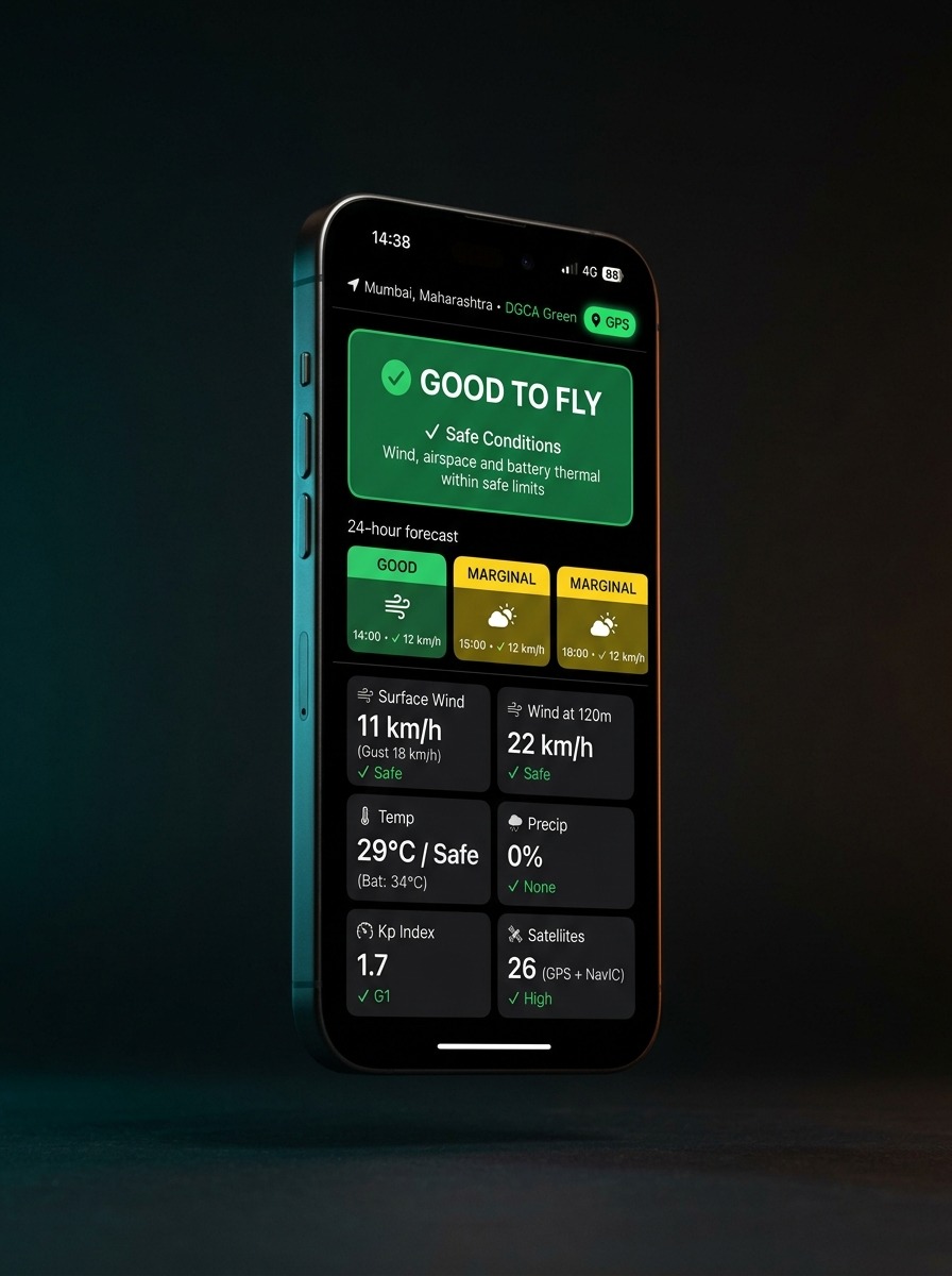
Now Verdict & 12 Aeronautical Cells
Open the app and get an instant GO / CAUTION / NO-GO verdict before takeoff with the exact reason (e.g. 'Gusts 34 km/h too strong for small drones').
- 10m surface wind, gusts, and 120m aloft wind profile
- Cloud base, fog risk, humidity, temperature, and feels-like
- Kp solar geomagnetic index and GNSS satellite availability
- Best flight window today coloured by hourly flying safety
DGCA Airspace & Indian Zone Map
Answers 'Can I fly here legally?' for wherever you stand, with direct contacts for local authorities.
- Live Green, Yellow, and Red zone overlays across India
- Distance to nearest airport, heliport, or defence facility
- Direct phone and email for local ATC units and IAF/Navy contacts
- Pre-filled permission request letter PDF ready to share
KML Survey Maker & Boundary Walker
Draw flight plans or walk the actual field boundary with your phone GPS to calculate exact survey areas.
- Walk-the-boundary GPS perimeter tracking on the ground
- Real-time area readouts in Guntha, Bigha, Acres, and Hectares
- Estimated flight time, battery count, and weather overlap
- Export directly to KML, KMZ, GeoJSON, and DJI Pilot 2 / QGC
Offline SOP Cards & 1-Tap SOS
Critical field emergency guides that load instantly even without an internet connection in remote rural areas.
- Offline emergency SOPs: fly-away, compass error, motor loss, battery fire
- 1-tap SOS: send live GPS coordinates via WhatsApp or SMS to ground crew
- One-touch call to the nearest hospital and police station
- Pre-flight and post-flight checklists per drone category
Compliance Wallet & Flight Logbook
Keep all your DGCA legal documents in your pocket for inspection by local police or site security.
- Offline QR wallet for Remote Pilot Certificate (RPC) and UIN
- Third-party insurance and type certificate storage with expiry alerts
- Digital flight logbook with DJI .txt and ArduPilot .bin import
- Battery health register with charge cycle tracking and heat history
India & Global Drone News + Tenders
Stay informed on civil aviation circulars, DGCA updates, and verified commercial opportunities.
- Daily curated drone news feed covering India and international developments
- GeM government drone tenders and state agriculture subsidy circulars
- Verified pilot job board for survey, mapping, and agri spraying pilots
- Made-in-India component directory and certified OEM marketplace
From private Alpha
to field standard.
Private Pilot Alpha
Closed testing with DGCA remote pilots, survey engineers, and agri operators on TestFlight (iOS) and APK (Android).
Public App Store Release
Public availability on Google Play & Apple App Store. Free 2-day tier and ₹499/year or ₹2,500 Lifetime Pro subscriptions.
Cloud Telemetry & Fleet Sync
Automated DJI Pilot 2 & ArduPilot cloud logbook sync, AI anomaly diagnosis, and GeM government tender push notifications.
“Pesticide droplets evaporate before hitting the crop in 38°C midday heat. The Delta-T calculation is something foreign apps never had.”
“Local land records in Gujarat are strictly in Guntha and Bigha. Being able to walk the perimeter and get exact local units will save hours of manual math.”
“Police checkpoints in rural survey areas always ask for drone papers. Having an offline QR card for RPC and UIN without waiting for 4G is huge.”
Tell us what you want in UAV Wingman.
UAV Wingman is built for pilots who fly in real conditions: 42°C heatwaves, sudden monsoons, remote rural farms, and DGCA compliance checks. We are pricing UAV Wingman at just ₹499/year or ₹2,499 for Lifetime access.
Frequently asked questions
about UAV Wingman.
What is UAV Wingman?
UAV Wingman is an aeronautical weather, airspace, and flight safety mobile app engineered by Voltair Tech for Indian drone pilots, fixed-wing operators, and survey teams. It replaces expensive foreign apps with an affordable, India-first tool.
Why is UAV Wingman priced at ₹499/year or ₹2,499 for a Lifetime plan?
International apps like UAV Forecast and Aloft price for US and European corporate budgets in USD ($30 to $50/yr), yet offer zero Indian airspace or local weather features. Voltair Tech is making professional flight tools accessible to every Indian pilot, student, and drone company at ₹499/year or ₹2,499 for permanent Lifetime access.
How does the 1-Year Free Pro feature reward work?
If you submit a feature suggestion or workflow through our feedback form or LinkedIn post and our engineering team integrates it into the UAV Wingman app, you will be awarded a complimentary 1-Year UAV Wingman Pro subscription.
What features are included in the Free tier?
The free tier includes full GO / CAUTION / NO-GO flight verdicts, 2-day hourly aeronautical weather (today and tomorrow), DGCA airspace zone checks, the KML survey drawer, offline emergency SOP cards, and the pilot compliance wallet.
Does UAV Wingman replace DigitalSky for legal flight permissions?
No. DigitalSky remains the statutory legal portal for Government of India airspace permissions. UAV Wingman provides fast, convenient operational awareness in the field, helping you verify your zone, understand permitted heights, contact local ATC units, and generate pre-filled permission letters.
Will UAV Wingman work without an internet connection in remote areas?
Yes. UAV Wingman caches your last forecast for offline access. The compliance wallet, emergency SOP cards, land unit calculators, magnetic declination model, and walk-the-boundary GPS tool work completely offline without cellular data.
How can I test the Alpha version or request a specific feature?
UAV Wingman is currently in active development. You can submit your feature requests and join the private Alpha TestFlight (iOS) and Android APK testing circle using the feedback form on this page.